The Medieval Landscape of Healey
Stephen Moorhouse
The medieval period runs from the end of the Roman period about 410 to about 1500. Historians and archaeologists divide the period in two. That from about 410 to the Norman Conquest in 1066 is termed The Early Medieval Period, while that from 1066 to about 1500 The High Medieval Period. The latter period provides an ever-increasing body and diversity of documentary evidence for understanding the ever-developing economy, society and landscape. Until the Industrial Revolution of about 1800 most of the lower classes were farmers. As such the landscape has been changing constantly, through successive chronological archaeological and historic periods. Farming requires a static fixed landscape that provides the full range of farming requirements essential to farmers: arable, enclosed grazing, meadow, woodland and common grazing. Each would be sited on particular types of soils and their underlying geologies. Hence arable would be concentrated on rich productive well drained soils, while woodland and rough grazing would be on the poorer quality soils. As geologies vary so does the concentration of types of farming – cereal in open field production in the Vale of York and grazing in enclosed small fields in the Pennines. Each community would still have the same range of resources, but in very different proportions. This has a direct impact on the pattern of the landscape. A glance at the Huddersfield 1inch OS map Sheet 102 will see a marked difference in the road concentration between the right-hand and left-hand sides of the map. This is because fewer roads are necessary in mainly arable areas than in enclosed areas to the west, where there were many more aspects to the township landscape, where access within and between them was necessary, and the topography was much more undulating, as in Batley.
From the earliest settled populations, at the start of the Neolithic period about 4000 BC, farming communities worked within boundaries, each of which contained the full range of farming resources but in different proportions depending on their geological setting. These varied and changed as each cultural community appeared through time. The closer we get to the modern day, the greater parts of earlier landscapes survive in what we see today. The landscape of the High Middle Ages forms the largest proportion of the landscape under our feet today. It is also the earliest period when we can identify the form and layout of landscapes with precision, through the discipline of the Landscape Historian, and the many resources which they use, such as documentary evidence, maps and place-names, which are not available in earlier periods. The farming organisation of the landscape in this period was by townships, very similar to our modern civil parishes. Batley was a medieval township. Apart from containing farming resources, the township was the unit within which people were taxed and manors operated. The township also contained features over which the manor had control which the tenants were obliged to use to the benefit of the lord, such as (in the case of Batley and many other townships), the wastes or commons, the water powered corn mill, the archery butts and the common oven. These were resources which (apart from the commons and archery butts) the tenants had to pay to use, providing a regular source of income for the over lord. Failure to do so would lead to a fine in the manor court. As we will see below, as the landscape was divided up into hamlet divisions, each with their own farming systems, so the farming landscape became fragmented into what we see on the 1st ed 6inch OS map. It is an appreciation of this process that allows us to understand the historic landscape. This will be discussed in a detailed book on the medieval landscape of Batley, which will appear later this year. The resources that the manor controlled before the hamlets were created survived through after the territorial hamlets were created and the tenants of the hamlets were obliged to use these facilities of the over lord as before.
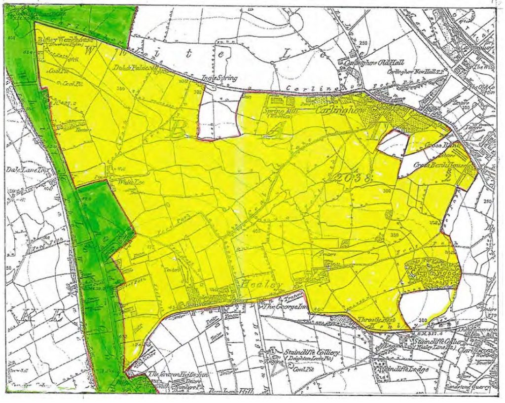
The accompanying figure shows the hamlet of Healey highlighted in yellow, based on the 1st ed 6inch OS map, surveyed in 1847-51. First edition maps were the first accurately surveyed maps to be produced. This can be seen by comparing the 1839 map of Batley with the 1st ed 6inch OS map of the same area surveyed about ten years earlier, which will appear in the forthcoming book. The1st ed 6inch OS map should always be used for understanding historic landscapes and as a basis for their understanding as they contain a range of features which survive through often from the medieval period, and even earlier, whose functions were not used when the maps were surveyed. These obsolete features, such as boundaries, were deleted when the first revision took place, usually towards the end of the 19th century. It is essential, therefore, to use the 1st ed 6in maps. A range of conventions were created to identify features on the maps. A hierarchy of fonts and point sizes were created to identify what names refer to, while a series of line conventions and their thicknesses defined particular types of boundaries. Acquaintance with these will allow the reader to use the 1st ed 6inch map as an essential tool for understanding the medieval landscape. A key to both these will appear in the forthcoming book, together with a discussion of how they have been used to identify and understand the medieval landscape of Batley.
The northern boundary of Healey was defined by Carlinghow Lane. With its extensions of Moffat Lane to the west and Blakeridge Road, Upper Commercial Street, Commercial Street and Hicks Lane to the east, it forms the oldest road in the region, and formed the backbone in the creation of the landscape of Batley township and of its development. If not of Roman origin, it was certainly created in The Early Medieval Period, and probably early in that period. The remaining boundaries have been identified from similar work carried out across Yorkshire over the past half century. The position of the settlement of Healey indicates one such boundary. Small villages such as Healey lie along their village street (Healey Lane) which forms the boundary between the territorial hamlets of Healey and what was called Woodhouses until the mid-18th century when its name changed to the present Staincliffe. Space will not allow a discussion of the development of the village, which will appear in the proposed book.
Routeways were an essential part of any Pennine township. They provided access between the essential parts of the township/hamlet, and between these and the settlement. Some of these have already been mentioned. A number are shown on the 1st ed 6inch OS map and are shown on the attached figure. Some survive, such the medieval field route running parallel and to the west of Deighton Lane. Originally a route through the arable fields of Woodhouses (now called Staincliffe), it also provided access for the Healey tenants to the commons south of Woodhouses, entering these by a funnel on Bunkers Lane, now built over. The route still survives as the footpath running down the rear of the gardens of houses fronting onto Fountains Avenue. It crosses West Park Road, known to locals as the ‘Healey Bypass (as it by-passed the village centre on Healey Lane), through the ginnel up to Healey Lane, exiting nearly opposite the Mini Market. Its origin probably dates to the late Saxon period. The slightly reverse ‘S’ curved form (characteristic of medieval arable fields) of the original path has been straightened to conform with the layout of the modern housing, the original clearly seen on the figure. The other important route was from the settlement of Healey to the parish church. Each of the settlements in Batley had their own discreet ‘kirkgates’, some of which survive while others do not. The Healey route does not. As seen on the figure the Healey kirkgate runs, typically of early routes, down the point of a projecting spur. Much of this route has been built over by the cemetery and housing estate. The only surviving section is where it leaves Healey Lane, passing through the buildings of Healey House. This small section is called significantly ‘Towngate’, meaning the route from the settlement. It is cobbled, one of the few surviving stretches of cobbling in the area.
The proposed book on the medieval landscape of Batley, mentioned above, will provide much more evidence for Healey, as well as placing the settlement and territorial hamlet into the setting of the remaining five hamlets and the township in which they lay.
© Stephen Moorhouse 2026